GOCA-Projects
GOCA-System for monitoring during the tunnel-tubes extension of the Kaiser Wilhelm railway tunnel at Cochem
Download Paper GOCA Monitoring Cochem Tunnel (pdf, 4,3 MB)
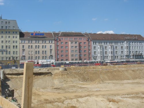
Geomonitoring New Construction Train Mainstation Vienna, Company Angst, Vienna
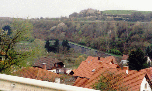
Monitoring of a building complex at Bruck an der Leitha
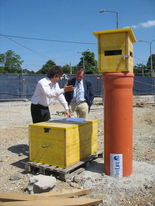
The GOCA system is currently applied by the Vermessung Angst ZT GmbH Company, Vienna for the geodetic online monitoring of an old barracks complex at Bruck an der Leitha. After subsidences and underpinning of the complex the online monitoring is done since begin of 2010 with the GOCA system. The purpose of the monitoring is to detect horizontal and height changes in the domain of the basement vault. The monitoring also includes an alerting by a local siren and an alarm management by SMS. The TCP/IP based control of the Leica Geosystems totalstation is done with the hard-und software VMT_TPSControlBox which was developed in cooperation with the GOCA partner VMT-GmBH, Bruchsal. The GOCA system which is installed locally is monitored remote from the office of the Vermessung Angst company in Vienna. The communication design alows - besides the local access on the continuous numerical and graphical results of the time series with trend estimation and 3D-displacement estimation - in this configuration also the access for authorised 3rd party users on the GOCA deformation state estimations.
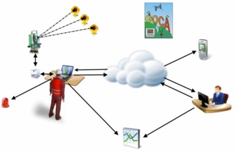
Left: Proile of the building complex with basement vault.
Right: Communication design of the monitoring network with link to the GOCA
deformation analysis software.
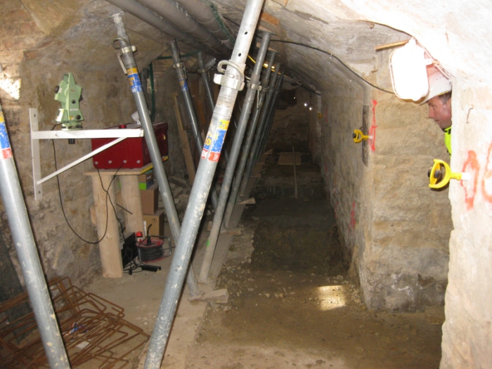
Basement vault with TPS-Sensor and object point prisms on the right. The TPS targets at the stable points outside the building (right).
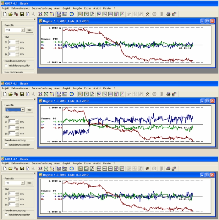
The object point time series resulting from the network adjustment with the GOCA deformation analysis software (GOCA Step 2). These are the input for the deformation analysis GOCA step 3. Red: Height changes. Blue and green: horizontal changes
Download Poster GOCA Geomonitoring Project "Jäger-Kaserne Bruck an der Leitha" (3 MB)
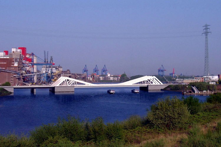
Geodetic Geomonitoring Rethe-Hub-Brücke
Geodetic Monitoring of the Moscow Kremlin. Deformationsanalysis with GOCA and GOCA-Virtual-Sensor
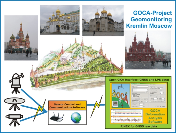
Poster: Geodetic Monitoring of the Moscow Kremlin (pdf, 0,5 MB)
GOCA-Project St. Petersburg
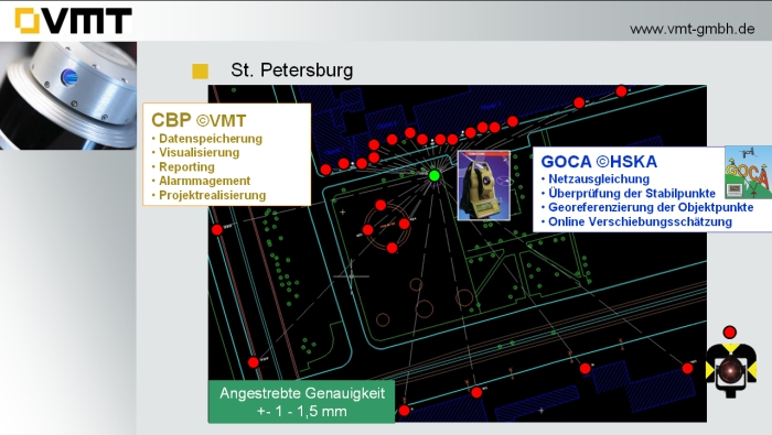
The GOCA cooperation partner VMT GmbH Bruchsal is using the GOCA-system together with the geoinformation system CBP of VMT GmbH since June 2009 for the geo-monitoring of a construction slot in the Russian town of St. Petersburg.
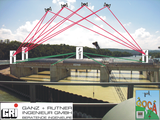
GOCA-Monitoring of the new Power Station Rheinfelden
Since spring 2005 the GOCA-System has been rented in cooperation with GOCA partner DrBertges for the monitoring and deformation analysis of the new power station Weir Rheinfelden by Ganz&Rutner Ingenieur GmbH (GRI). GNSS/GPS und terrestrial sensors (totalstations and levelling instruments) area applied. As concerns GNSS/GPS L1/L2 530 and 1200 sensors of Leica Geoystems are used. The GOCA monitoring network is designed to provide a threedimensional accuracy for horizontal and vertical displacements of less than 2-3 mm and a respective high sensitivity. A discrete epochwise use of the GOCA-systems in a half-year cycle has been planned.
The monitoring network for the new power station Weir Rheinfelden consists of 8 long-term stable GNSS/GPS reference points, which are partly situated far outside of the moving area of the bed of the river Rhein and a salt exploitation domain and is designed for a 100 years monitoring duration. The 5 GNSS-object points are linked to the further object-points of the Weir Rheinfelden by LPS-measurements (totalstations, levelling instruments) (figure).
The epochmeasurements are performed by using the online telemetric mode as well as the nearonline mode of the GOCA-system and the GOCA-software©GOCA-Team Karlsruhe, respectively. The powerful mathematical model of a strict multistep and network-adjustment based deformation, which is implemented in the GOCA-Software, enables to set up the GPS-basestations during the measurements in the unstable objectpoint domain, to achieve short and high accurate GNSS-baselines. Occurring displacements of the GNNS/GPS-basestation are automatically considered and properly modelled in the mathematical model of the GOCA-software.
In the object-point area of the weir construction the GNSS/GPS-measurements are completed by terrestrial measurements, which can be combined in the GOCA-software, version 4.0 with GNSS/GPS-data.
The data acquisition for GNSS/GPS and LPS is done by the software GOCA_DC3 ©DrBertges, and is based on the open GOCA-software interface GKA.
All epoch adjustments, the statistical analysis of the stability of the reference points, as well as the statistically based strict displacement estimation as object of the deformation analysis are performed at Ganz&Rutner by using the GOCA-software.
Die next measurement epoch at Weir Rheinfelden with the GOCA-system will take place in November 2005. Those who are interested in a participation at the GOCA-measurements, including a life presentation of the GOCA-system, are asked to get into contact with the Ganz&Rutner company.
The new Power Station Rheinfelden is constructed by
Energiedienst AG
![]()
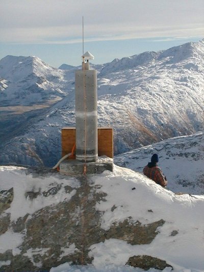
GPS-Monitoring Gotthard Alp Transit Tunnel Project
The Tasks
With
a lenght of 57 km the Gotthard-Basis-Tunnel in Switzerland will the longest
railway tunnel of the world.
The GPS-based monitoring system GOCA is situated in the tunnel area and
has to provide a permanent automatic monitoring and deformation
analysis with respect to the detection and modeling of e.g. subsidences, tilts
and valley convergences or divergences processes, which may occur during the
construction of the Gotthard railway tunnel. Amon others the most relevant
taks for the GOCA system are:
|
|
 |
| Construction Area
Gotthard-BasisTunnel near Sedrun, Graubünden Phot © AlpTransit Gotthard AG |
Monitoring Area Rondadura/ Lai Blau below Sta.-Maria water-reservoir |
Monitoring and Detection of 3-dimensional Displacements
Different Sampling Rates according to the Phases and the Progress of Construction
Offline and near realtime Monitoring and Deformation Modeling
Date Transmission by Radio-Telemetry and GSM
Central Processing of the Data
The Solution
GPS-based full automatic area monitoring of the worlds longest railway tunnel with the GOCA Deformationsanalysis Software together with the data aquisition- and communikations system GOCA-DC3.
The GOCA-Software works in a long-distance remote control mode and realizes an online deformationsanalysis based on a strict network adjustement of different types of sensor-data - namely baselines-vectors (and raw data) and total stations data - using a clear defined open data interface. Based on the division of the sensor array into a stable and an object area the adjustment provides die 3-dimensional coordinates of the object-points in the reference datum of the stable points. The resulting object-point time series are visualized and submitted to least squares and robust filters and trend estimations, e.g. Kalman-Filtering, and the respective results are also shown in graphic windows. An automatic alarm is to be realized by the user-defined setting of a critical 3-dimensional state vector for the displacements only and for displacements-velocities-acceleartions of the object points.
The communications-
and datenacquisition system GOCA-DC3 of Dr. Bertges, Vermessungstechnik
allows to handle the link of the GOCA software to different
kind of sensors and communication channels. GOCA-DC3
consists of at least on central processing unit (so-called data
concentrator) and several external sensor control units.
GOCA-DC3 is has a modulary and scalable design and allows a quick
adaption and extension to the users request even during the operation
mode. The aquisition of the sensor data (GPS, Total-Stations) may take
place in a real-time, near-online and an offline mode. The data-change
with the GOCA -Software may run online or offline.
The sampling rates and
the observation design are to be choosen in a variable mode.
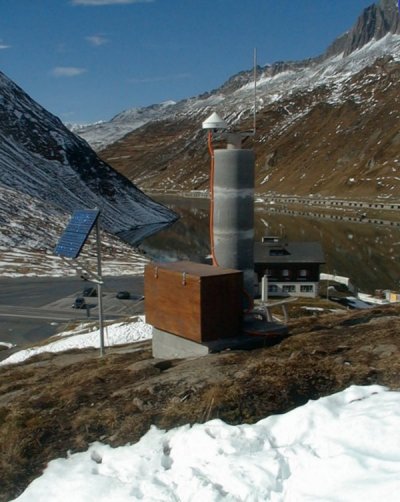
|
|
|
| GOCA-Monitoring. GPS-station in the Sta.-Maria water-reservoir area | GOCA-Monitoring. GPS-station in Oberalp area |
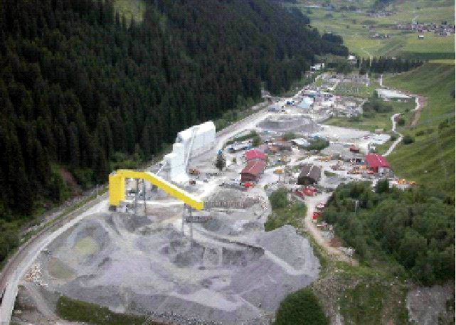
GOCA-Monitoring of a Factory-Area in Cooporation with RWE Rheinbraun Köln, Germany
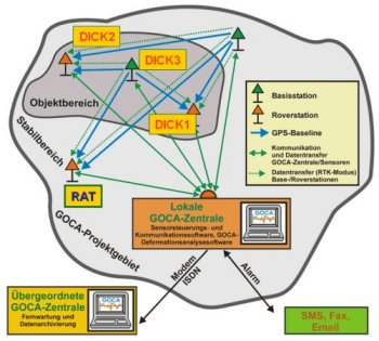
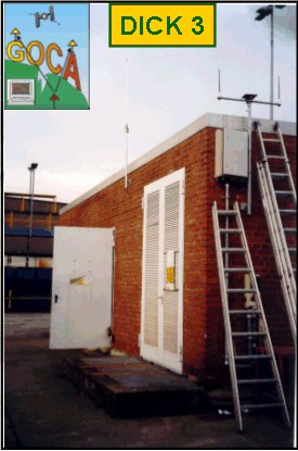
Since 11th December 2002 the GOCA-System is installed at a factory area using five GPS-sensors (DICK3 and RAT with L1/L2-MR2 receivers of the GeoNav company, the other three object points with L1 GeoNav-GOCA receivers of the Karlsruhe University of Applied Sciences). The aim is to detect deformations - especially in the height-component - in context with a nearby situated open-cast mining area. The figure below (left side) shows the monitoring design, the figure on the right shows the GPS reference-station DICK3, which is acting as an object point.
Precise levelling is carried out for the control of the height-deformations determined with the GOCA-system. The previous investigations show a correspondance of the height-deformations detected with GOCA and the precise levelling in the mm-sensitivity-range.
|
|
|
| Overview of the Monitoring Area | GPS-Monitoring-Station DICK3 |
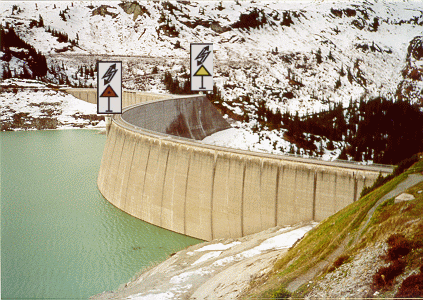
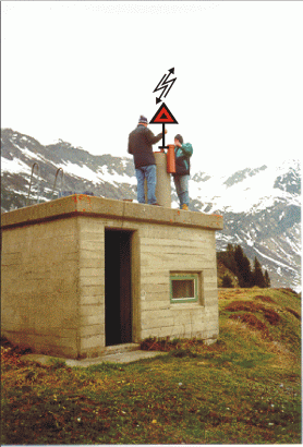
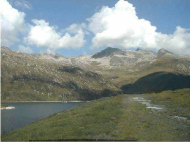
Monitoring of Kops Dam. Illwerke Vorarlberg, Austria.
| Since May 2001 the Kops Dam of Austrian Illwerke
Vorarlberg/Austria is monitored with the GOCA-System. Three GPS-Sensors are installed:
two on object points and one on a stable point. Object points are situated
in the
artificial counter bearing of the dam (yellow,
GPS-Reference station) and the middle of the dam arc (red, Rover 1).
The stable reference point (red, Rover 2) is shown in the figure right.
Kops Dam with 2 GPS-Sensors |
Stable Reference Point installed as a rover station |
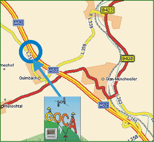
Glan-Münchweiler, Monitoring of Slope in dangerous zone by Highway A62. BAB-Administration & GeoInternational
| The system GOCA is going to be installed next
in Quirnbach near Glan-Münchweiler in commition of the German highway administration and
as a project
of GeoInternational, Mainz. The purpose of the GOCA installation is
a long-time "Monitoring and Alert" functionality in the
respective landslide area.
The slope below the highway A62 moves "only" few cm per year, the resulting damage is however clearly recognizable, e.g. by the displacement of the retaining wall (figure below, left). |
 |
|
Disalignment of the retaining wall |
Total view on the endangered slope below the German highway A62 |
Online-Monitoring of the
Lohwies-Hall in Reisbach/Saarland (Subsidence Area)
in cooperation with the Deutsche Steinkohle AG (DSK)
Classical GPS-Measurements in the Subsidence Area
Reisbach
Due to the continuous undermining and the excavation of coal in this area, a
subsidence-hollow arises at the earths surface. As the deformations endanger the stability
of buildings, a permanent monitoring of the subsidence area is necessary. To prove those
deformations in Reisbach/Saarland (figure below) a classical
deformation network was established in this area in the frame of a diploma thesis
running at the Karlsruhe University of Technology. In Spring 1999 the area was observed by
GPS measurements for a duration of 3 months in 6 measurment epochs. Deformations in the plan component of up to 25 cm and in the height component of up to 90 cm
were detected during this period.
Deformation Monitoring in the Subsidence Area Reisbach with GOCA
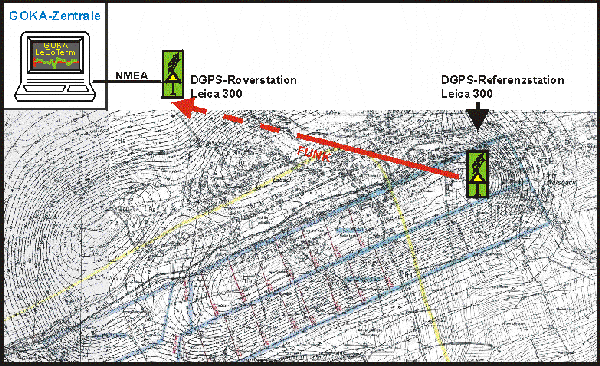
| From August 2nd 1999 to February 7th 2000 discrete object, the Lohwies-Hall in Reisbach was monitored with GOCA. In the case of monitoring the Lohwies-Hall (figure right), the receiver hardware consisted of two Leica 300 sensors. The reference station was installed on the roof of the Lohwies-Hall (object point) and the rover sensor was located on the roof of the northern shaft (reference point) of the mine Ensdorf (figure above). The data transmission between reference station and rover station was done by a radio modem. The NMEA data of the rover sensor was transmitted by data cable to the personal computer in the GOCA-Center. The interface software LeGoTerm received the data and provided them for the further processing to the GOCA deformation analysis software. |
|
Results of the Monitoring
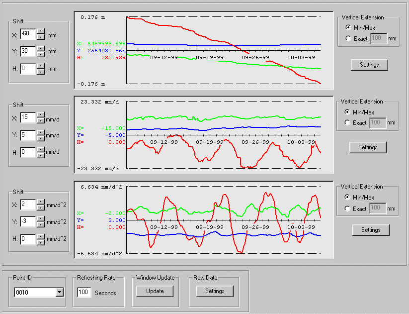
The figures below show the time-series of the object-point at the Lohwies-Hall determined by GOCA in the period from August 2nd1999 to February 7th 2000. Based on a spline-adjustment a trend-estimation was computed with the GOCA-Software for Northern, Eastern (figure on the top) and Height (figure on the bottom).
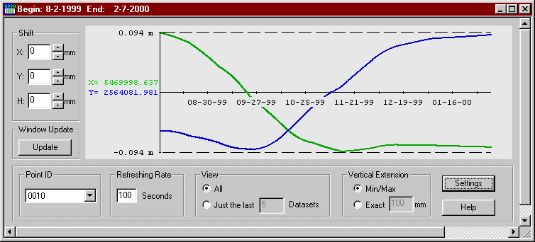
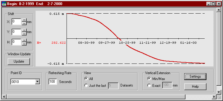
The deformations for the period from August 2nd 1999 to February 7th 2000 are:
| Height | Eastern | Northern |
| 1.23 m | 0.18 m | 0.19 m |
The maximum deformation-rate is:
| Height | Easten | Northern |
| 20 mm/Tag | 1.5 mm/Tag | 2.0 mm/Tag |
With the GOCA-Kalman-Filter-module an estimation of position, velocity and accelerration was computed for a selected epoch of five weeks. The figure below shows the resulting object-point-time-series. The graphic-window for the Kalman-Filter results is similar to the standard graphic window and contains the diagrams for position (top), velocity (middle) and acceleration (bottom). As the mining-activities are interrupted at the weekend, the time-series show the resulting delays respective the accelerations in the subsidence-process at the earths surface.
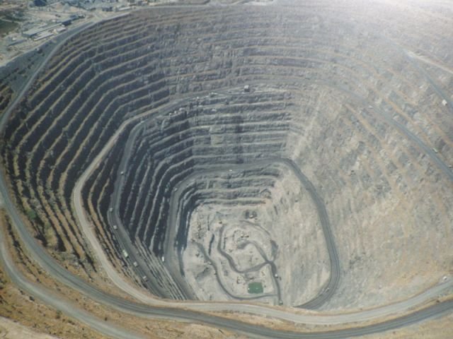
Online - Monitoring of the Palabora-Copper-Mine in South-Africa
Since November 2004 the GOCA-System is used for the monitoring of the Palabora-Coppermine in South-Africa with Trimble-Equipement (Trimble GeoNav, Optron / South-Africa)