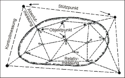
Observations in GOCA are the three-dimensional baseline-vectors, distance- or angle-measurements with thier covariance-matrix related to one ore more GNSS-Base- or TPS-Station(s). These observations are transformed, in case of GNSS-Observations, in twodimensional plan- and one-dimensional height-baselines with consideration of the law of error-propagation. TPS-Observations are reduced to a projection ellipsoid. If necessary, height-integration-parameters are calculated with shared GNSS/TPS points. Are one ore more GNSS-Base- or TPS-Stations detected to be unstable when checking the reference points, their coordinates have to be introduced in the following as unknowns during the estimation of object point coordinates by means of least-squares-adjustment. Therefore it is not necessary to set up the GNSS-Base- or TPS-Stations in the stable area of the deformation network.
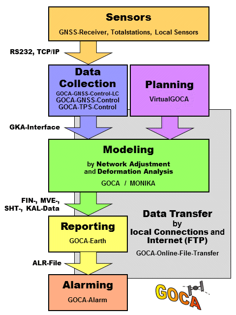
A communication and hardware-control-sofware based on the GKA-data-interface is responsible for the communication between GOCA-defomrationanalysis-software and the sensor-component. For GNSS- and TPS-Sensors, the modules GOCA-GNSS-Control and GOCA-TPS-Control are available.
The GOCA-software does - besides the initialisation, georeferencing and checking of stable-points - a deformationanalysis (trend estimation, kalman-filtering, FEM) with respct to the object-points participating at the monitoring. Over and above that an alarmmanagement and a deformation-prediction is provided by the GOCA-Software.